Informacja

Drogi użytkowniku, aplikacja do prawidłowego działania wymaga obsługi JavaScript. Proszę włącz obsługę JavaScript w Twojej przeglądarce.

Wyszukujesz frazę "Niemcy. Reichsamt für Landesaufnahme. Redaktor" wg kryterium: Autor


Tytuł:
Karte des Deutschen Reiches. 31, Gr. Skaisgirren
Karte des Deutschen Reiches 1:100 000 ; 31
Autorzy:
Niemcy. Reichsamt für Landesaufnahme. Redaktor Wydawca
Data publikacji:
1924
Wydawca:
Reichsamt für Landesaufnahme
Słowa kluczowe:
Drezno (Niemcy) -- 1900-1945 -- mapy [KABA]
topographic maps
Drezno (Germany)
1900-1945
Mapy topograficzne -- 1900-1945 [KABA]
Pokaż więcej
Dostawca treści:
RCIN - Repozytorium Cyfrowe Instytutów Naukowych
Materiały ikonograficzne
Tytuł:
Karte des Deutschen Reiches 1:100 000 ; 134
Karte des Deutschen Reiches 1:100 000, 134. Allenstein
Autorzy:
Niemcy. Reichsamt für Landesaufnahme. Redaktor Wydawca
Data publikacji:
1939
Wydawca:
Reichsamt für Landesaufnahme
Słowa kluczowe:
Mapy topograficzne -- 1900-1945 [KABA]
Olsztyn (Polska, województwo warmińsko-mazurskie ; region) -- mapy [KABA]
Pokaż więcej
Dostawca treści:
RCIN - Repozytorium Cyfrowe Instytutów Naukowych
Materiały ikonograficzne
Tytuł:
Karte des Deutschen Reiches 1:100 000, 445. Zittau
Karte des Deutschen Reiches 1:100 000 ; 445
Autorzy:
Niemcy. Reichsamt für Landesaufnahme. Redaktor. Wydawca
Data publikacji:
1940
Wydawca:
Reichsamt für Landesaufnahme
Słowa kluczowe:
Mapy topograficzne -- 1900-1945 [KABA]
topographic maps
Żytawa (Niemcy ; region) -- mapy [KABA]
Żytawa (Germany)
Pokaż więcej
Dostawca treści:
RCIN - Repozytorium Cyfrowe Instytutów Naukowych
Materiały ikonograficzne
Tytuł:
Karte des Deutschen Reiches 1:100 000, 494. Kurort Oberwiesenthal
Karte des Deutschen Reiches 1:100 000 ; 494
Autorzy:
Niemcy. Reichsamt für Landesaufnahme. Redaktor
Niemcy. Reichsamt für Landesaufnahme. Zweigstelle Landesaufnahme Sachsen. Redaktor
Data publikacji:
1937
Wydawca:
wydawca nieznany
Słowa kluczowe:
Kurort Oberwiesenthal (Niemcy ; region) -- mapy [KABA]
topographic maps
1900-1945
Mapy topograficzne -- 1900-1945 [KABA]
Kurort Oberwiesenthal (Germany ; region)
Pokaż więcej
Dostawca treści:
RCIN - Repozytorium Cyfrowe Instytutów Naukowych
Materiały ikonograficzne
Tytuł:
Karte des Deutschen Reiches 1:100 000, 514. Selb
Karte des Deutschen Reiches 1:100 000 ; 514
Autorzy:
Niemcy. Reichsamt für Landesaufnahme. Zweigstelle Landesaufnahme Sachsen. Redaktor
Niemcy. Reichsamt für Landesaufnahme. Redaktor Wydawca
Data publikacji:
1941
Wydawca:
Reichsamt für Landesaufnahme
Słowa kluczowe:
Mapy topograficzne -- 1900-1945 [KABA]
topographic maps
Selb (Niemcy ; region) -- mapy [KABA]
Selb (Germany)
Pokaż więcej
Dostawca treści:
RCIN - Repozytorium Cyfrowe Instytutów Naukowych
Materiały ikonograficzne
Tytuł:
Karte des Deutschen Reiches 1:100 000, 544. Worms
Karte des Deutschen Reiches 1:100 000 ; 544
Autorzy:
Niemcy. Reichsamt für Landesaufnahme. Redaktor
Prusy. Landesaufnahme. Redaktor
Hesja (Niemcy ; land). Landesvermessungsamt. Redaktor. Wydawca
Data publikacji:
1954
Wydawca:
Hessisches Landesvermessungsamt
Słowa kluczowe:
Wormacja (Niemcy ; region) -- mapy [KABA]
Wormacja (Germany)
Mapy topograficzne -- 1945-1990 [KABA]
topographic maps
Pokaż więcej
Dostawca treści:
RCIN - Repozytorium Cyfrowe Instytutów Naukowych
Materiały ikonograficzne
Tytuł:
Karte des Deutschen Reiches 1:100 000 ; 545
Karte des Deutschen Reiches 1:100 000, 545. Miltenberg
Autorzy:
Niemcy. Reichsamt für Landesaufnahme. Redaktor
Prusy. Landesaufnahme. Redaktor
Hesja (Niemcy ; land). Landesvermessungsamt. Redaktor. Wydawca
Data publikacji:
1949
Wydawca:
Hessisches Landesvermessungsamt
Słowa kluczowe:
Miltenberg (Germany)
Mapy topograficzne -- 1945-1990 [KABA]
topographic maps
Miltenberg (Niemcy ; region) -- mapy [KABA]
Pokaż więcej
Dostawca treści:
RCIN - Repozytorium Cyfrowe Instytutów Naukowych
Materiały ikonograficzne
Tytuł:
Karte des Deutschen Reiches 1:100 000, 460. Gießen
Karte des Deutschen Reiches 1:100 000 ; 460
Autorzy:
Niemcy. Reichsamt für Landesaufnahme. Redaktor
Prusy. Landesaufnahme. Redaktor
Hesja (Niemcy ; land). Landesvermessungsamt. Redaktor. Wydawca
Data publikacji:
1951
Wydawca:
Hessisches Landesvermessungsamt
Słowa kluczowe:
1945-1990
topographic maps
Giessen (Germany)
Giessen (Niemcy ; region) -- mapy [KABA]
Mapy topograficzne -- 1945-1990 [KABA]
Pokaż więcej
Dostawca treści:
RCIN - Repozytorium Cyfrowe Instytutów Naukowych
Materiały ikonograficzne
Tytuł:
Karte des Deutschen Reiches 1:100 000, 469. Annaberg
Karte des Deutschen Reiches 1:100 000 ; 469
Autorzy:
Niemcy. Reichsamt für Landesaufnahme. Zweigstelle Landesaufnahme Sachsen. Redaktor
Niemcy. Reichsamt für Landesaufnahme. Redaktor Wydawca
Data publikacji:
1937
Wydawca:
Reichsamt für Landesaufnahme
Słowa kluczowe:
Annaberg-Buchholz (Germany ; region)
Mapy topograficzne -- 1900-1945 [KABA]
topographic maps
Annaberg-Buchholz (Niemcy ; region) -- mapy [KABA]
Pokaż więcej
Dostawca treści:
RCIN - Repozytorium Cyfrowe Instytutów Naukowych
Materiały ikonograficzne
Tytuł:
Karte des Deutschen Reiches 1:100 000 ; 485
Karte des Deutschen Reiches 1:100 000, 485. Friedberg
Autorzy:
Niemcy. Reichsamt für Landesaufnahme. Redaktor
Prusy. Landesaufnahme. Redaktor
Hesja (Niemcy ; land). Landesvermessungsamt. Redaktor. Wydawca
Data publikacji:
1951
Wydawca:
Hessisches Landesvermessungsamt
Słowa kluczowe:
Friedberg (Germany)
1945-1990
topographic maps
Friedberg (Niemcy, land Hesja ; region) -- mapy [KABA]
Mapy topograficzne -- 1945-1990 [KABA]
Pokaż więcej
Dostawca treści:
RCIN - Repozytorium Cyfrowe Instytutów Naukowych
Materiały ikonograficzne
Tytuł:
Karte des Deutschen Reiches 1:100 000 ; 461
Karte des Deutschen Reiches 1:100 000, 461. Grünberg
Autorzy:
Niemcy. Reichsamt für Landesaufnahme. Redaktor
Prusy. Landesaufnahme. Redaktor
Hesja (Niemcy ; land). Landesvermessungsamt. Redaktor. Wydawca
Data publikacji:
1949
Wydawca:
Hessisches Landesvermessungsamt
Słowa kluczowe:
1945-1990
Grünberg (Niemcy ; region) -- mapy [KABA]
topographic maps
Mapy topograficzne -- 1945-1990 [KABA]
Grünberg (Germany ; region)
Pokaż więcej
Dostawca treści:
RCIN - Repozytorium Cyfrowe Instytutów Naukowych
Materiały ikonograficzne
Tytuł:
Karte des Deutschen Reiches 1:100 000 ; 416
Karte des Deutschen Reiches 1:100 000, 416. Döbeln
Autorzy:
Niemcy. Reichsamt für Landesaufnahme. Zweigstelle Landesaufnahme Sachsen. Wydawca
Niemcy. Reichsamt für Landesaufnahme. Redaktor Wydawca
Saksonia. Generalstab. Topographisches Bureau. Redaktor
Data publikacji:
1940
Wydawca:
Reichsamt für Landesaufnahme
Słowa kluczowe:
topographic maps
1900-1945
Döbeln (Niemcy ; region) -- mapy [KABA]
Mapy topograficzne -- 1900-1945 [KABA]
Döbeln (Germany)
Pokaż więcej
Dostawca treści:
RCIN - Repozytorium Cyfrowe Instytutów Naukowych
Materiały ikonograficzne
Tytuł:
Karte des Deutschen Reiches, 494. Oberwiesenthal
Karte des Deutschen Reiches ; 494
Autorzy:
Niemcy. Reichsamt für Landesaufnahme. Wydawca
Niemcy. Reichsamt für Landesaufnahme. Zweigstelle Landesaufnahme Sachsen. Redaktor. Wydawca
Data publikacji:
1925
Wydawca:
Reichsamt für Landesaufnahme : Landesaufnahme Sachsen
Słowa kluczowe:
Kurort Oberwiesenthal (Niemcy ; region) -- mapy [KABA]
topographic maps
1900-1945
Mapy topograficzne -- 1900-1945 [KABA]
Kurort Oberwiesenthal (Germany ; region)
Pokaż więcej
Dostawca treści:
RCIN - Repozytorium Cyfrowe Instytutów Naukowych
Materiały ikonograficzne
Tytuł:
Karte des Deutschen Reiches 1:100 000 ; 246
Karte des Deutschen Reiches 1:100 000, 246. Königsberg i.d. Neum.
Autorzy:
Niemcy. Reichsamt für Landesaufnahme. Wydawca
Prusy. Landesaufnahme. Redaktor
Data publikacji:
1940
Wydawca:
Reichsamt für Landesaufnahme
Słowa kluczowe:
Chojna region
Chojna (Polska, województwo zachodniopomorskie ; region) -- mapy [KABA]
topographic maps
1900-1945
Mapy topograficzne -- 1900-1945 [KABA]
Pokaż więcej
Dostawca treści:
RCIN - Repozytorium Cyfrowe Instytutów Naukowych
Materiały ikonograficzne
Tytuł:
Karte des Deutschen Reiches 1:100 000, 486. Büdingen
Karte des Deutschen Reiches 1:100 000 ; 486
Autorzy:
Niemcy. Reichsamt für Landesaufnahme. Wydawca
Prusy. Landesaufnahme. Redaktor
Data publikacji:
1936
Wydawca:
Reichsamt für Landesaufnahme
Słowa kluczowe:
Büdingen (Germany)
topographic maps
1900-1945
Mapy topograficzne -- 1900-1945 [KABA]
Büdingen (Niemcy ; region) -- mapy [KABA]
Pokaż więcej
Dostawca treści:
RCIN - Repozytorium Cyfrowe Instytutów Naukowych
Materiały ikonograficzne
Tytuł:
Karte des Deutschen Reiches 1:100 000, 93. Kolberg
Karte des Deutschen Reiches 1:100 000 ; 93
Autorzy:
Niemcy. Reichsamt für Landesaufnahme. Wydawca
Prusy. Landesaufnahme. Redaktor
Data publikacji:
1938
Wydawca:
Reichsamt für Landesaufnahme
Słowa kluczowe:
Mapy topograficzne -- 1900-1945 [KABA]
Kołobrzeg (Polska ; region) -- mapy [KABA]
Pokaż więcej
Dostawca treści:
RCIN - Repozytorium Cyfrowe Instytutów Naukowych
Materiały ikonograficzne
Tytuł:
Karte des Deutschen Reiches 1:100 000 ; 507
Karte des Deutschen Reiches 1:100 000, 507. Frankfurt a. M.
Autorzy:
Niemcy. Reichsamt für Landesaufnahme. Wydawca
Prusy. Landesaufnahme. Redaktor
Data publikacji:
1951
Wydawca:
Reichsamt für Landesaufnahme
Słowa kluczowe:
Frankfurt nad Menem (Niemcy ; region) -- mapy [KABA]
topographic maps
1945-1900
Mapy topograficzne -- 1945-1990 [KABA]
Frankfurt am Men
Pokaż więcej
Dostawca treści:
RCIN - Repozytorium Cyfrowe Instytutów Naukowych
Materiały ikonograficzne
Tytuł:
Karte des Deutschen Reiches 1:100 000 ; 644
Karte des Deutschen Reiches 1:100 000, 644. Freiburg i Breisgau
Autorzy:
Niemcy. Reichsamt für Landesaufnahme. Wydawca
Prusy. Landesaufnahme. Redaktor
Data publikacji:
1940
Wydawca:
Reichsamt für Landesaufnahme
Słowa kluczowe:
Fryburg Bryzgowijski (Niemcy ; region) -- mapy [KABA]
topographic maps
1900-1945
Fryburg Bryzgowijski (Germany)
Mapy topograficzne -- 1900-1945 [KABA]
Pokaż więcej
Dostawca treści:
RCIN - Repozytorium Cyfrowe Instytutów Naukowych
Materiały ikonograficzne
Tytuł:
Karte des Deutschen Reiches 1:100 000 ; 125
Karte des Deutschen Reiches 1:100 000, 125. Bad Polzin
Autorzy:
Niemcy. Reichsamt für Landesaufnahme. Wydawca
Prusy. Landesaufnahme. Redaktor
Data publikacji:
1940
Wydawca:
Reichsamt für Landesaufnahme
Słowa kluczowe:
Połczyn-Zdrój (Polska ; region) -- mapy [KABA]
Mapy topograficzne -- 1900-1945 [KABA]
Pokaż więcej
Dostawca treści:
RCIN - Repozytorium Cyfrowe Instytutów Naukowych
Materiały ikonograficzne
Tytuł:
Karte des Deutschen Reiches 1:100 000, 558. Mannheim
Karte des Deutschen Reiches 1:100 000 ; 558
Autorzy:
Niemcy. Reichsamt für Landesaufnahme. Wydawca
Prusy. Landesaufnahme. Redaktor
Data publikacji:
1940
Wydawca:
Reichsamt für Landesaufnahme
Słowa kluczowe:
Mannheim (Germany ; region)
Mapy topograficzne -- 1900-1945 [KABA]
topographical maps
Mannheim (Niemcy ; region) -- mapy [KABA]
Pokaż więcej
Dostawca treści:
RCIN - Repozytorium Cyfrowe Instytutów Naukowych
Materiały ikonograficzne
Tytuł:
Karte des Deutschen Reiches ; 573
Karte des Deutschen Reiches, 573. Karlsruhe
Autorzy:
Niemcy. Reichsamt für Landesaufnahme. Wydawca
Prusy. Landesaufnahme. Redaktor
Data publikacji:
1935
Wydawca:
Reichsamt für Landesaufnahme
Słowa kluczowe:
topographic maps
Karlsruhe (Niemcy ; region) -- mapy [KABA]
1900-1945
Karlsruhe (Germany)
Mapy topograficzne -- 1900-1945 [KABA]
Pokaż więcej
Dostawca treści:
RCIN - Repozytorium Cyfrowe Instytutów Naukowych
Materiały ikonograficzne
Tytuł:
Karte des Deutschen Reiches 1:100 000, 124. Schivelbein
Karte des Deutschen Reiches 1:100 000 ; 124
Autorzy:
Niemcy. Reichsamt für Landesaufnahme. Wydawca
Prusy. Landesaufnahme. Redaktor
Data publikacji:
1938
Wydawca:
Reichsamt für Landesaufnahme
Słowa kluczowe:
Mapy topograficzne -- 1900-1945 [KABA]
Świdwin (Polska ; region) -- mapy [KABA]
Pokaż więcej
Dostawca treści:
RCIN - Repozytorium Cyfrowe Instytutów Naukowych
Materiały ikonograficzne
Tytuł:
Karte des Deutschen Reiches ; 323. Wollstein
Karte des Deutschen Reiches ; 323
Autorzy:
Niemcy. Reichsamt für Landesaufnahme. Wydawca
Prusy. Landesaufnahme. Redaktor
Data publikacji:
1936
Wydawca:
Reichsamt für Landesaufnahme
Słowa kluczowe:
Wolsztyn (Polska ; region) -- mapy [KABA]
Mapy topograficzne -- 1900-1945 [KABA]
topographic maps
Wolsztyn (Poland)
Pokaż więcej
Dostawca treści:
RCIN - Repozytorium Cyfrowe Instytutów Naukowych
Materiały ikonograficzne
Tytuł:
Karte des Deutschen Reiches, 413. Naumburg
Karte des Deutschen Reiches 1:100 000 ; 413
Autorzy:
Niemcy. Reichsamt für Landesaufnahme. Wydawca
Prusy. Landesaufnahme. Redaktor
Data publikacji:
1924
Wydawca:
Reichsamt für Landesaufnahme
Słowa kluczowe:
Mapy topograficzne -- 1900-1945 [KABA]
Naumburg (Germany)
topographic maps
Naumburg (Niemcy ; region) -- mapy [KABA]
Pokaż więcej
Dostawca treści:
RCIN - Repozytorium Cyfrowe Instytutów Naukowych
Materiały ikonograficzne
Tytuł:
Karte des Deutschen Reiches 1:100 000, 301. Posen
Karte des Deutschen Reiches 1:100 000 ; 301
Autorzy:
Niemcy. Reichsamt für Landesaufnahme. Wydawca
Prusy. Landesaufnahme. Redaktor
Data publikacji:
1940
Wydawca:
Reichsamt für Landesaufnahme
Słowa kluczowe:
Poznań (Polska ; region) -- mapy [KABA]
topographic maps
1900-1945
Mapy topograficzne -- 1900-1945 [KABA]
Poznań (Poland)
Pokaż więcej
Dostawca treści:
RCIN - Repozytorium Cyfrowe Instytutów Naukowych
Materiały ikonograficzne
Tytuł:
Karte des Deutschen Reiches 1:100 000, 105. Rastenburg
Karte des Deutschen Reiches 1:100 000 ; 105
Autorzy:
Niemcy. Reichsamt für Landesaufnahme. Wydawca
Prusy. Landesaufnahme. Redaktor
Data publikacji:
1939
Wydawca:
Reichsamt für Landesaufnahme
Słowa kluczowe:
Kętrzyn (Polska ; region) -- mapy [KABA]
Mapy topograficzne -- 1900-1945 [KABA]
Pokaż więcej
Dostawca treści:
RCIN - Repozytorium Cyfrowe Instytutów Naukowych
Materiały ikonograficzne
Tytuł:
Karte des Deutschen Reiches 1:100 000, 146. Schwerin i Meckl.
Karte des Deutschen Reiches 1:100 000 ; 146
Autorzy:
Niemcy. Reichsamt für Landesaufnahme. Wydawca
Prusy. Landesaufnahme. Redaktor
Data publikacji:
1924
Wydawca:
Reichsamt für Landesaufnahme
Słowa kluczowe:
Mapy topograficzne -- 1900-1945 [KABA]
Schwerin (Niemcy ; region) -- mapy [KABA]
Pokaż więcej
Dostawca treści:
RCIN - Repozytorium Cyfrowe Instytutów Naukowych
Materiały ikonograficzne
Tytuł:
Karte des Deutschen Reiches ; 456
Karte des Deutschen Reiches, 456. Euskirchen
Autorzy:
Niemcy. Reichsamt für Landesaufnahme. Wydawca
Prusy. Landesaufnahme. Redaktor
Data publikacji:
1936
Wydawca:
Reichsamt für Landesaufnahme
Słowa kluczowe:
Euskirchen (Germany)
topographic maps
1900-1945
Mapy topograficzne -- 1900-1945 [KABA]
Euskirchen (Niemcy ; region) -- mapy [KABA]
Pokaż więcej
Dostawca treści:
RCIN - Repozytorium Cyfrowe Instytutów Naukowych
Materiały ikonograficzne
Tytuł:
Karte des Deutschen Reiches 1:100 000 ; 249
Karte des Deutschen Reiches 1:100 000, 249. Filehne
Autorzy:
Niemcy. Reichsamt für Landesaufnahme. Wydawca
Prusy. Landesaufnahme. Redaktor
Data publikacji:
1941
Wydawca:
Reichsamt für Landesaunahme
Słowa kluczowe:
Wieleń (Polska, powiat czarnkowsko-trzcianecki ; region) -- mapy [KABA]
Mapy topograficzne -- 1900-1945 [KABA]
Pokaż więcej
Dostawca treści:
RCIN - Repozytorium Cyfrowe Instytutów Naukowych
Materiały ikonograficzne
Tytuł:
Karte des Deutschen Reiches 1:100 000. 48. Gr. Bruch,72. Braunsberg
Karte des Deutschen Reiches 1:100 000 ; 48, 72
Autorzy:
Niemcy. Reichsamt für Landesaufnahme. Wydawca
Prusy. Landesaufnahme. Redaktor
Data publikacji:
1940
Wydawca:
Reichsamt für Landesaufnahme
Słowa kluczowe:
Mapy topograficzne -- 1900-1945 [KABA]
Braniewo (Polska ; region) -- mapy [KABA]
Pokaż więcej
Dostawca treści:
RCIN - Repozytorium Cyfrowe Instytutów Naukowych
Materiały ikonograficzne
Tytuł:
Karte des Deutschen Reiches 1:100 000. Prenzlau
Karte des Deutschen Reiches 1:100 000
[186]. Prenzlau
Karte des Deutschen Reiches 1:100 000 ; [186]
Autorzy:
Niemcy. Reichsamt für Landesaufnahme. Wydawca
Prusy. Landesaufnahme. Redaktor
Data publikacji:
1936
Wydawca:
Reichsamt für Landesaufnahme
Słowa kluczowe:
Mapy topograficzne -- 1900-1945 [KABA]
Prenzlau (Niemcy ; region) -- mapy [KABA]
Pokaż więcej
Dostawca treści:
RCIN - Repozytorium Cyfrowe Instytutów Naukowych
Materiały ikonograficzne
Tytuł:
Karte des Deutschen Reiches ; 274
Karte des Deutschen Reiches, 274. Birnbaum
Autorzy:
Niemcy. Reichsamt für Landesaufnahme. Wydawca
Prusy. Landesaufnahme. Redaktor
Data publikacji:
1926
Wydawca:
Reichsamt für Landesaunahme
Słowa kluczowe:
Międzychód (Polska, powiat międzychodzki ; region) -- mapy [KABA]
Mapy topograficzne -- 1900-1945 [KABA]
topographic maps
Międzychód county
Pokaż więcej
Dostawca treści:
RCIN - Repozytorium Cyfrowe Instytutów Naukowych
Materiały ikonograficzne
Tytuł:
Karte des Deutschen Reiches 1:100 000, 325. Schrimm
Karte des Deutschen Reiches 1:100 000 ; 325
Autorzy:
Niemcy. Reichsamt für Landesaufnahme. Wydawca
Prusy. Landesaufnahme. Redaktor
Data publikacji:
1941
Wydawca:
Reichsamt für Landesaufnahme
Słowa kluczowe:
topographic maps
Mapy topograficzne -- 1900-1945 [KABA]
Śrem (Poland)
Śrem (Polska, województwo wielkopolskie ; region) -- mapy [KABA]
Pokaż więcej
Dostawca treści:
RCIN - Repozytorium Cyfrowe Instytutów Naukowych
Materiały ikonograficzne
Tytuł:
Karte des Deutschen Reiches ; 375
Karte des Deutschen Reiches, 375. Krotoschin
Autorzy:
Niemcy. Reichsamt für Landesaufnahme. Wydawca
Prusy. Landesaufnahme. Redaktor
Data publikacji:
1934
Wydawca:
Reichsamt für Landesaufnahme
Słowa kluczowe:
topographic maps
1900-1945
Krotoszyn (Polska, województwo wielkopolskie ; region) -- mapy [KABA]
Mapy topograficzne -- 1900-1945 [KABA]
Krotoszyn (Poland ; region)
Pokaż więcej
Dostawca treści:
RCIN - Repozytorium Cyfrowe Instytutów Naukowych
Materiały ikonograficzne
Tytuł:
Karte des Deutschen Reiches 1:100 000, 45. Ladenburg in Pom.
Karte des Deutschen Reiches 1:100 000 ; 45
Autorzy:
Niemcy. Reichsamt für Landesaufnahme. Wydawca
Prusy. Landesaufnahme. Redaktor
Data publikacji:
1939
Wydawca:
Reichsamt für Landesaufnahme
Słowa kluczowe:
Lębork (Polska ; region) -- mapy [KABA]
Mapy topograficzne -- 1900-1945 [KABA]
Pokaż więcej
Dostawca treści:
RCIN - Repozytorium Cyfrowe Instytutów Naukowych
Materiały ikonograficzne
Tytuł:
Karte des Deutschen Reiches 1:100 000, 413. Naumburg
Karte des Deutschen Reiches 1:100 000 ; 413
Autorzy:
Niemcy. Reichsamt für Landesaufnahme. Wydawca
Prusy. Landesaufnahme. Redaktor
Data publikacji:
1931
Wydawca:
Reichsamt für Landesaufnahme
Słowa kluczowe:
Mapy topograficzne -- 1900-1945 [KABA]
Naumburg (Germany)
topographic maps
Naumburg (Niemcy ; region) -- mapy [KABA]
Pokaż więcej
Dostawca treści:
RCIN - Repozytorium Cyfrowe Instytutów Naukowych
Materiały ikonograficzne
Tytuł:
Karte des Deutschen Reiches 1:100 000 ; 346
Karte des Deutschen Reiches 1:100 000, 346. Grünberg i. Schl.
Autorzy:
Niemcy. Reichsamt für Landesaufnahme. Wydawca
Prusy. Landesaufnahme. Redaktor
Data publikacji:
1941
Wydawca:
Reichsamt für Landesaufnahme
Słowa kluczowe:
Zielona Góra (Poland)
Zielona Góra (Polska ; region) -- mapy [KABA]
Mapy topograficzne -- 1900-1945 [KABA]
topographic maps
Pokaż więcej
Dostawca treści:
RCIN - Repozytorium Cyfrowe Instytutów Naukowych
Materiały ikonograficzne
Tytuł:
Karte des Deutschen Reiches 1:100 000, 347. Fraustadt
Karte des Deutschen Reiches 1:100 000 ; 347
Autorzy:
Niemcy. Reichsamt für Landesaufnahme. Wydawca
Prusy. Landesaufnahme. Redaktor
Data publikacji:
1941
Wydawca:
Reichsamt für Landesaufnahme
Słowa kluczowe:
Wschowa (Polska ; region) -- mapy [KABA]
topographic maps
Mapy topograficzne -- 1900-1945 [KABA]
Wschowa (Poland)
Pokaż więcej
Dostawca treści:
RCIN - Repozytorium Cyfrowe Instytutów Naukowych
Materiały ikonograficzne
Tytuł:
Karte des Deutschen Reiches 1:100 000, 188. Stargard i. Pom.
Karte des Deutschen Reiches 1:100 000 ; 188
Autorzy:
Niemcy. Reichsamt für Landesaufnahme. Wydawca
Prusy. Landesaufnahme. Redaktor
Data publikacji:
1934
Wydawca:
Reichsamt für Landesaufnahme
Słowa kluczowe:
Mapy topograficzne -- 1900-1945 [KABA]
Stargard (Polska ; region) -- mapy [KABA]
Pokaż więcej
Dostawca treści:
RCIN - Repozytorium Cyfrowe Instytutów Naukowych
Materiały ikonograficzne
Tytuł:
Karte des Deutschen Reiches 1:100 000 ; 348
Karte des Deutschen Reiches 1:100 000, 348. Lissa
Autorzy:
Niemcy. Reichsamt für Landesaufnahme. Wydawca
Prusy. Landesaufnahme. Redaktor
Data publikacji:
1941
Wydawca:
Reichsamt für Landesaufnahme
Słowa kluczowe:
Leszno (Polska, województwo wielkopolskie ; region) -- mapy [KABA]
topographic maps
1900-1945
Mapy topograficzne -- 1900-1945 [KABA]
Leszno (Poland ; region)
Pokaż więcej
Dostawca treści:
RCIN - Repozytorium Cyfrowe Instytutów Naukowych
Materiały ikonograficzne
Tytuł:
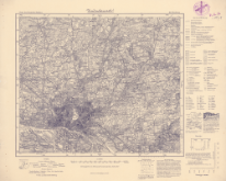
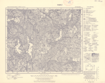
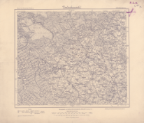
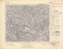
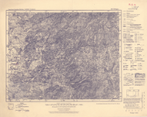
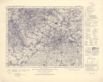
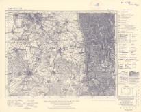
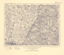
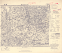
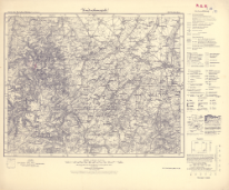
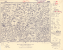
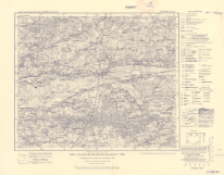
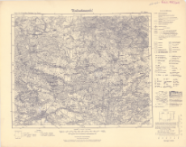
Karte des Deutschen Reiches 1:100 000, 77. Goldap
Karte des Deutschen Reiches 1:100 000 ; 77
Autorzy:
Niemcy. Reichsamt für Landesaufnahme. Wydawca
Prusy. Landesaufnahme. Redaktor
Data publikacji:
[1940]
Wydawca:
Reichsamt für Landesaufnahme
Słowa kluczowe:
Mapy topograficzne -- 1900-1945 [KABA]
Gołdap (Polska ; region) -- mapy [KABA]
Pokaż więcej
Dostawca treści:
RCIN - Repozytorium Cyfrowe Instytutów Naukowych
Materiały ikonograficzne
Tytuł:
Karte des Deutschen Reiches 1:100 000, 483. Koblenz
Karte des Deutschen Reiches 1:100 000 ; 483
Autorzy:
Niemcy. Reichsamt für Landesaufnahme. Wydawca
Prusy. Landesaufnahme. Redaktor
Data publikacji:
1940
Wydawca:
Reichsamt für Landesaufnahme
Słowa kluczowe:
Koblencja (Germany)
Koblencja (Niemcy ; region) -- mapy [KABA]
topographic maps
1900-1945
Mapy topograficzne -- 1900-1945 [KABA]
Pokaż więcej
Dostawca treści:
RCIN - Repozytorium Cyfrowe Instytutów Naukowych
Materiały ikonograficzne
Tytuł:
Karte des Deutschen Reiches 1:100 000, 343. Lübben
Karte des Deutschen Reiches 1:100 000 ; 343
Autorzy:
Niemcy. Reichsamt für Landesaufnahme. Wydawca
Prusy. Landesaufnahme. Redaktor
Data publikacji:
1939
Wydawca:
Reichsamt für Landesaufnahme
Słowa kluczowe:
Lublin (Polska ; region) -- mapy [KABA]
topographic maps
1900-1945
Mapy topograficzne -- 1900-1945 [KABA]
Lublin (Poland ; region)
Pokaż więcej
Dostawca treści:
RCIN - Repozytorium Cyfrowe Instytutów Naukowych
Materiały ikonograficzne
Tytuł:
Karte des Deutschen Reiches 1:100 000, 374. Rawitsch
Karte des Deutschen Reiches 1:100 000 ; 374
Autorzy:
Niemcy. Reichsamt für Landesaufnahme. Wydawca
Prusy. Landesaufnahme. Redaktor
Data publikacji:
1940
Wydawca:
Reichsamt für Landesaufnahme
Słowa kluczowe:
topographic maps
Rawicz (Polska, województwo wielkopolskie ; region) -- mapy [KABA]
Mapy topograficzne -- 1900-1945 [KABA]
Rawicz (Poland)
Pokaż więcej
Dostawca treści:
RCIN - Repozytorium Cyfrowe Instytutów Naukowych
Materiały ikonograficzne
Tytuł:
Karte des Deutschen Reiches ; 370
Karte des Deutschen Reiches, 370. Sorau
Autorzy:
Niemcy. Reichsamt für Landesaufnahme. Wydawca
Prusy. Landesaufnahme. Redaktor
Data publikacji:
1929
Wydawca:
Reichsamt für Landesaufnahme
Słowa kluczowe:
Mapy topograficzne -- 1900-1945 [KABA]
Żary (Polska, województwo lubuskie ; region) -- mapy [KABA]
Żary (Poland)
topographic maps
Pokaż więcej
Dostawca treści:
RCIN - Repozytorium Cyfrowe Instytutów Naukowych
Materiały ikonograficzne
Tytuł:
Karte des Deutschen Reiches 1:100 000 ; 395
Karte des Deutschen Reiches 1:100 000, 395. Kohlfurt
Autorzy:
Niemcy. Reichsamt für Landesaufnahme. Wydawca
Prusy. Landesaufnahme. Redaktor
Data publikacji:
1938
Wydawca:
Reichsamt für Landesaufnahme
Słowa kluczowe:
Węgliniec (Polska ; region) -- mapy [KABA]
Mapy topograficzne -- 1900-1945 [KABA]
Pokaż więcej
Dostawca treści:
RCIN - Repozytorium Cyfrowe Instytutów Naukowych
Materiały ikonograficzne
Tytuł:
Karte des Deutschen Reiches, 65. Großmöllen
Karte des Deutschen Reiches ; 65
Autorzy:
Niemcy. Reichsamt für Landesaufnahme. Wydawca
Prusy. Landesaufnahme. Redaktor
Data publikacji:
1928
Wydawca:
Reichsamt für Landesaufnahme
Słowa kluczowe:
Mielno (Polska, powiat koszaliński ; region) -- mapy [KABA]
Mapy topograficzne -- 1900-1945 [KABA]
Pokaż więcej
Dostawca treści:
RCIN - Repozytorium Cyfrowe Instytutów Naukowych
Materiały ikonograficzne
Tytuł:
Karte des Deutschen Reiches 1:100 000 ; 92
Karte des Deutschen Reiches 1:100 000, 92. Treptow a.d. Rega
Autorzy:
Niemcy. Reichsamt für Landesaufnahme. Wydawca
Prusy. Landesaufnahme. Redaktor
Data publikacji:
1941
Wydawca:
Reichsamt für Landesaufnahme
Słowa kluczowe:
Mapy topograficzne -- 1900-1945 [KABA]
Trzebiatów (Polska ; region) -- mapy [KABA]
Pokaż więcej
Dostawca treści:
RCIN - Repozytorium Cyfrowe Instytutów Naukowych
Materiały ikonograficzne
Tytuł:
Karte des Deutschen Reiches ; 126
Karte des Deutschen Reiches, 126. Bublitz
Autorzy:
Niemcy. Reichsamt für Landesaufnahme. Wydawca
Prusy. Landesaufnahme. Redaktor
Data publikacji:
1941
Wydawca:
Reichsamt für Landesaufnahme
Słowa kluczowe:
Mapy topograficzne -- 1900-1945 [KABA]
Bobolice (Polska, województwo zachodniopomorskie ; region) -- mapy [KABA]
Pokaż więcej
Dostawca treści:
RCIN - Repozytorium Cyfrowe Instytutów Naukowych
Materiały ikonograficzne
Tytuł:
Karte des Deutschen Reiches 1:100 000, 127. Baldenburg
Karte des Deutschen Reiches 1:100 000 ; 127
Autorzy:
Niemcy. Reichsamt für Landesaufnahme. Wydawca
Prusy. Landesaufnahme. Redaktor
Data publikacji:
1941
Wydawca:
Reichsamt für Landesaufnahme
Słowa kluczowe:
Biały Bór (Polska, województwo zachodniopomorskie ; region) -- mapy [KABA]
Mapy topograficzne -- 1900-1945 [KABA]
Pokaż więcej
Dostawca treści:
RCIN - Repozytorium Cyfrowe Instytutów Naukowych
Materiały ikonograficzne
Tytuł:
Karte des Deutschen Reiches 1:100 000 ; 128
Karte des Deutschen Reiches 1:100 000, 128. Bruß
Autorzy:
Niemcy. Reichsamt für Landesaufnahme. Wydawca
Prusy. Landesaufnahme. Redaktor
Data publikacji:
1940
Wydawca:
Reichsamt für Landesaufnahme
Słowa kluczowe:
Brusy (Polska ; region) -- mapy [KABA]
Mapy topograficzne -- 1900-1945 [KABA]
Pokaż więcej
Dostawca treści:
RCIN - Repozytorium Cyfrowe Instytutów Naukowych
Materiały ikonograficzne
Tytuł:
Karte des Deutschen Reiches 1:100 000 ; 164
Karte des Deutschen Reiches 1:100 000, 164. Marienweder
Autorzy:
Niemcy. Reichsamt für Landesaufnahme. Wydawca
Prusy. Landesaufnahme. Redaktor
Data publikacji:
1940
Wydawca:
Reichsamt für Landesaufnahme
Słowa kluczowe:
Kwidzyn (Polska ; region) -- mapy [KABA]
Mapy topograficzne -- 1900-1945 [KABA]
Pokaż więcej
Dostawca treści:
RCIN - Repozytorium Cyfrowe Instytutów Naukowych
Materiały ikonograficzne
Tytuł:
Karte des Deutschen Reiches 1:100 000, 194. Crone a.d. Brahe
Karte des Deutschen Reiches 1:100 000 ; 194
Autorzy:
Niemcy. Reichsamt für Landesaufnahme. Wydawca
Prusy. Landesaufnahme. Redaktor
Data publikacji:
1940
Wydawca:
Reichsamt für Landesaufnahme
Słowa kluczowe:
Koronowo (Polska, województwo kujawsko-pomorskie ; region) -- mapy [KABA]
Mapy topograficzne -- 1900-1945 [KABA]
Pokaż więcej
Dostawca treści:
RCIN - Repozytorium Cyfrowe Instytutów Naukowych
Materiały ikonograficzne
Tytuł:
Karte des Deutschen Reiches 1:100 000 ; 481
Karte des Deutschen Reiches 1:100 000, 481. Hillesheim
Autorzy:
Niemcy. Reichsamt für Landesaufnahme. Wydawca
Prusy. Landesaufnahme. Redaktor
Data publikacji:
1951
Wydawca:
Reichsamt für Landesaufnahme
Słowa kluczowe:
Hillesheim (Germany ; region)
1945-1990
topographic maps
Hillesheim (Niemcy ; region) -- mapy [KABA]
Mapy topograficzne -- 1945-1990 [KABA]
Pokaż więcej
Dostawca treści:
RCIN - Repozytorium Cyfrowe Instytutów Naukowych
Materiały ikonograficzne
Tytuł:
Karte des Deutschen Reiches 1:100 000, 224. Nakel a.d. Netze
Karte des Deutschen Reiches 1:100 000 ; 224
Autorzy:
Niemcy. Reichsamt für Landesaufnahme. Wydawca
Prusy. Landesaufnahme. Redaktor
Data publikacji:
1940
Wydawca:
Reichsamt für Landesaufnahme
Słowa kluczowe:
Mapy topograficzne -- 1900-1945 [KABA]
Nakło nad Notecią (Polska ; region) -- mapy [KABA]
Pokaż więcej
Dostawca treści:
RCIN - Repozytorium Cyfrowe Instytutów Naukowych
Materiały ikonograficzne
Tytuł:
Karte des Deutschen Reiches 1:100 000 ; 149. Schwerin i Meckl.
Karte des Deutschen Reiches 1:100 000 ; 149
Autorzy:
Niemcy. Reichsamt für Landesaufnahme. Wydawca
Prusy. Landesaufnahme. Redaktor
Data publikacji:
1926
Wydawca:
Reichsamt für Landesaufnahme
Słowa kluczowe:
Mapy topograficzne -- 1900-1945 [KABA]
Schwerin (Niemcy ; region) -- mapy [KABA]
Pokaż więcej
Dostawca treści:
RCIN - Repozytorium Cyfrowe Instytutów Naukowych
Materiały ikonograficzne
Tytuł:
Karte des Deutschen Reiches 1:100 000, 196. Briesen
Karte des Deutschen Reiches 1:100 000 ; 196
Autorzy:
Niemcy. Reichsamt für Landesaufnahme. Wydawca
Prusy. Landesaufnahme. Redaktor
Data publikacji:
1941
Wydawca:
Reichsamt für Landesaufnahme
Słowa kluczowe:
Wąbrzeźno (Polska ; region) -- mapy [KABA]
Mapy topograficzne -- 1900-1945 [KABA]
Pokaż więcej
Dostawca treści:
RCIN - Repozytorium Cyfrowe Instytutów Naukowych
Materiały ikonograficzne
Tytuł:
Karte des Deutschen Reiches 1:100 000, 659. Konstanz
Karte des Deutschen Reiches 1:100 000 ; 659
Autorzy:
Niemcy. Reichsamt für Landesaufnahme. Wydawca
Prusy. Landesaufnahme. Redaktor
Data publikacji:
1940
Wydawca:
Reichsamt für Landesaufnahme
Słowa kluczowe:
Konstancja (Niemcy ; region) -- mapy [KABA]
Konstancja (Germany ; region)
topographic maps
1900-1945
Mapy topograficzne -- 1900-1945 [KABA]
Pokaż więcej
Dostawca treści:
RCIN - Repozytorium Cyfrowe Instytutów Naukowych
Materiały ikonograficzne
Tytuł:
Karte des Deutschen Reiches 1:100 000 ; 463
Karte des Deutschen Reiches 1:100 000, 463. Geisa
Autorzy:
Niemcy. Reichsamt für Landesaufnahme. Wydawca
Prusy. Landesaufnahme. Redaktor
Data publikacji:
1936
Wydawca:
Reichsamt für Landesaufnahme
Słowa kluczowe:
topographic maps
1900-1945
Mapy topograficzne -- 1900-1945 [KABA]
Geisa (Niemcy ; region) -- mapy [KABA]
Geisa (Germany)
Pokaż więcej
Dostawca treści:
RCIN - Repozytorium Cyfrowe Instytutów Naukowych
Materiały ikonograficzne
Tytuł:
Karte des Deutschen Reiches, 294. Schöneberg
Karte des Deutschen Reiches ; 294
Autorzy:
Niemcy. Reichsamt für Landesaufnahme. Wydawca
Prusy. Landesaufnahme. Redaktor
Data publikacji:
1920
Wydawca:
Reichsamt für Landesaufnahme
Słowa kluczowe:
Berlin (Niemcy ; region) -- mapy [KABA]
topographic maps
1900-1945
Berlin (Germany ; region)
Mapy topograficzne -- 1900-1945 [KABA]
Pokaż więcej
Dostawca treści:
RCIN - Repozytorium Cyfrowe Instytutów Naukowych
Materiały ikonograficzne
Tytuł:
Karte des Deutschen Reiches, 95. Pollnow
Karte des Deutschen Reiches ; 95
Autorzy:
Niemcy. Reichsamt für Landesaufnahme. Wydawca
Prusy. Landesaufnahme. Redaktor
Data publikacji:
1933
Wydawca:
Reichsamt für Landesaufnahme
Słowa kluczowe:
Polanów (Polska, województwo zachodniopomorskie ; region) -- mapy [KABA]
Mapy topograficzne -- 1900-1945 [KABA]
Pokaż więcej
Dostawca treści:
RCIN - Repozytorium Cyfrowe Instytutów Naukowych
Materiały ikonograficzne
Tytuł:
Karte des Deutschen Reiches. 2, Schattern
Karte des Deutschen Reiches 1:100 000 ; 2
Autorzy:
Niemcy. Reichsamt für Landesaufnahme. Wydawca
Prusy. Landesaufnahme. Redaktor
Data publikacji:
1916
Wydawca:
Reichsamt für Landesaufnahme
Słowa kluczowe:
Šatriai (Litwa ; region) -- mapy [KABA]
topographic maps
Mapy topograficzne -- 1900-1945 [KABA]
Korciany (Lithuania)
Šatriai (Lithuania)
Korciany (Litwa ; region) -- mapy [KABA]
Pokaż więcej
Dostawca treści:
RCIN - Repozytorium Cyfrowe Instytutów Naukowych
Materiały ikonograficzne
Tytuł:
Karte des Deutschen Reiches 1:100 000 ; 324
Karte des Deutschen Reiches 1:100 000, 324. Kosten
Autorzy:
Niemcy. Reichsamt für Landesaufnahme. Wydawca
Prusy. Landesaufnahme. Redaktor
Data publikacji:
1942
Wydawca:
Reichsamt für Landesaufnahme
Słowa kluczowe:
topographic maps
Kościan (Poland ; region)
1900-1945
Mapy topograficzne -- 1900-1945 [KABA]
Kościan (Polska ; region) -- mapy [KABA]
Pokaż więcej
Dostawca treści:
RCIN - Repozytorium Cyfrowe Instytutów Naukowych
Materiały ikonograficzne
Tytuł:
Karte des Deutschen Reiches 1:100 000, 209. Amelinghausen
Karte des Deutschen Reiches 1:100 000 ; 209
Autorzy:
Niemcy. Reichsamt für Landesaufnahme. Wydawca
Prusy. Landesaufnahme. Redaktor
Data publikacji:
1938
Wydawca:
Reichsamt für Landesaufnahme
Słowa kluczowe:
Mapy topograficzne -- 1900-1945 [KABA]
Amelinghausen (Niemcy ; region) -- mapy [KABA]
Pokaż więcej
Dostawca treści:
RCIN - Repozytorium Cyfrowe Instytutów Naukowych
Materiały ikonograficzne
Tytuł:
Karte des Deutschen Reiches ; 245
Karte des Deutschen Reiches, 245. Bad Freienwalde a.d. O
Autorzy:
Niemcy. Reichsamt für Landesaufnahme. Wydawca
Prusy. Landesaufnahme. Redaktor
Data publikacji:
1924
Wydawca:
Reichsamt für Landesaunahme
Słowa kluczowe:
Mapy topograficzne -- 1900-1945 [KABA]
Bad Freienwalde (Niemcy ; region) -- mapy [KABA]
Pokaż więcej
Dostawca treści:
RCIN - Repozytorium Cyfrowe Instytutów Naukowych
Materiały ikonograficzne
Tytuł:
Karte des Deutschen Reiches 1:100 000, 95. Pollnow
Karte des Deutschen Reiches 1:100 000 ; 95
Autorzy:
Niemcy. Reichsamt für Landesaufnahme. Wydawca
Prusy. Landesaufnahme. Redaktor
Data publikacji:
1941
Wydawca:
Reichsamt für Landesaufnahme
Słowa kluczowe:
Polanów (Polska, województwo zachodniopomorskie ; region) -- mapy [KABA]
Mapy topograficzne -- 1900-1945 [KABA]
Pokaż więcej
Dostawca treści:
RCIN - Repozytorium Cyfrowe Instytutów Naukowych
Materiały ikonograficzne
Tytuł:
Karte des Deutschen Reiches, 310. Hameln
Karte des Deutschen Reiches ; 310
Autorzy:
Niemcy. Reichsamt für Landesaufnahme. Wydawca
Prusy. Landesaufnahme. Redaktor
Data publikacji:
1927
Wydawca:
Reichsamt für Landesaufnahme
Słowa kluczowe:
Hameln (Germany ; region)
topographic maps
1900-1945
Hameln (Niemcy ; region) -- mapy [KABA]
Mapy topograficzne -- 1900-1945 [KABA]
Pokaż więcej
Dostawca treści:
RCIN - Repozytorium Cyfrowe Instytutów Naukowych
Materiały ikonograficzne
Tytuł:
Karte des Deutschen Reiches ; 397
Karte des Deutschen Reiches, 397. Lüben
Autorzy:
Niemcy. Reichsamt für Landesaufnahme. Wydawca
Prusy. Landesaufnahme. Redaktor
Data publikacji:
1936
Wydawca:
Reichsamt für Landesaufnahme
Słowa kluczowe:
topographic maps
1900-1945
Lubin (Poland ; region)
Mapy topograficzne -- 1900-1945 [KABA]
Lubin (Polska, województwo dolnośląskie ; region) -- mapy [KABA]
Pokaż więcej
Dostawca treści:
RCIN - Repozytorium Cyfrowe Instytutów Naukowych
Materiały ikonograficzne
Tytuł:
Karte des Deutschen Reiches, 395. Kohlfurt
Karte des Deutschen Reiches ; 395
Autorzy:
Niemcy. Reichsamt für Landesaufnahme. Wydawca
Prusy. Landesaufnahme. Redaktor
Data publikacji:
1937
Wydawca:
Reichsamt für Landesaufnahme
Słowa kluczowe:
Węgliniec (Polska ; region) -- mapy [KABA]
Mapy topograficzne -- 1900-1945 [KABA]
topographic maps
Węgliniec (Poland)
Pokaż więcej
Dostawca treści:
RCIN - Repozytorium Cyfrowe Instytutów Naukowych
Materiały ikonograficzne
Tytuł:
Karte des Deutschen Reiches, 389. Halle
Karte des Deutschen Reiches ; 389
Autorzy:
Niemcy. Reichsamt für Landesaufnahme. Zweigstelle Landesaufnahme Sachsen. Redaktor
Data publikacji:
1922
Wydawca:
wydawca nieznany
Słowa kluczowe:
Halle (Germany ; region)
topographic maps
1900-1945
Mapy topograficzne -- 1900-1945 [KABA]
Halle (Niemcy ; region) -- mapy [KABA]
Pokaż więcej
Dostawca treści:
RCIN - Repozytorium Cyfrowe Instytutów Naukowych
Materiały ikonograficzne
Tytuł:
Karte des Deutschen Reiches ; 273
Karte des Deutschen Reiches, 273. Schwerin a.d. W.
Autorzy:
Niemcy. Reichsamt für Landesaufnahme. Wydawca
Prusy. Landesaufnahme. Redaktor
Data publikacji:
1934
Wydawca:
Reichsamt für Landesaufnahme
Słowa kluczowe:
Skwierzyna (Polska ; region) -- mapy [KABA]
Mapy topograficzne -- 1900-1945 [KABA]
topographic maps
Skwierzyna (Poland)
Pokaż więcej
Dostawca treści:
RCIN - Repozytorium Cyfrowe Instytutów Naukowych
Materiały ikonograficzne
Tytuł:
Karte des Deutschen Reiches 1:100 000 ; 279
Karte des Deutschen Reiches 1:100 000, 279. Popowo
Autorzy:
Niemcy. Reichsamt für Landesaufnahme. Wydawca
Prusy. Landesaufnahme. Redaktor
Data publikacji:
1941
Wydawca:
Reichsamt für Landesaunahme
Słowa kluczowe:
Radziejów (Polska, województwo kujawsko-pomorskie ; region) -- mapy [KABA]
Mapy topograficzne -- 1900-1945 [KABA]
topographic maps
Radziejów (Poland)
Pokaż więcej
Dostawca treści:
RCIN - Repozytorium Cyfrowe Instytutów Naukowych
Materiały ikonograficzne
Tytuł:
Karte des Deutschen Reiches ; 293
Karte des Deutschen Reiches, 293. Potsdam
Autorzy:
Niemcy. Reichsamt für Landesaufnahme. Wydawca
Prusy. Landesaufnahme. Redaktor
Data publikacji:
1925
Wydawca:
Reichsamt für Landesaunahme
Słowa kluczowe:
Poczdam (Niemcy ; region) -- mapy [KABA]
Mapy topograficzne -- 1900-1945 [KABA]
topographic maps
Poczdam (Germany)
Pokaż więcej
Dostawca treści:
RCIN - Repozytorium Cyfrowe Instytutów Naukowych
Materiały ikonograficzne
Tytuł:
Karte des Deutschen Reiches 1:100 000, 498. Neisse (Ost)
Karte des Deutschen Reiches 1:100 000 ; 498
Autorzy:
Niemcy. Reichsamt für Landesaufnahme. Wydawca
Prusy. Landesaufnahme. Redaktor
Data publikacji:
1939
Wydawca:
Reichsamt für Landesaufnahme
Słowa kluczowe:
Mapy topograficzne -- 1900-1945 [KABA]
Nysa (Polska ; region) -- mapy [KABA]
Pokaż więcej
Dostawca treści:
RCIN - Repozytorium Cyfrowe Instytutów Naukowych
Materiały ikonograficzne
Tytuł:
Karte des Deutschen Reiches 1:100 000, 349. Gostyn
Karte des Deutschen Reiches 1:100 000 ; 349
Autorzy:
Niemcy. Reichsamt für Landesaufnahme. Wydawca
Prusy. Landesaufnahme. Redaktor
Data publikacji:
1940
Wydawca:
Reichsamt für Landesaufnahme
Słowa kluczowe:
Gostyń (Polska, województwo wielkopolskie ; region) -- mapy [KABA]
topographic maps
1900-1945
Mapy topograficzne -- 1900-1945 [KABA]
Gostyń (Poland ; region)
Pokaż więcej
Dostawca treści:
RCIN - Repozytorium Cyfrowe Instytutów Naukowych
Materiały ikonograficzne
Tytuł:
Karte des Deutschen Reiches 1:100 000 ; 160
Karte des Deutschen Reiches 1:100 000, 160. Preuß. Friedland
Autorzy:
Niemcy. Reichsamt für Landesaufnahme. Wydawca
Prusy. Landesaufnahme. Redaktor
Data publikacji:
1941
Wydawca:
Reichsamt für Landesaufnahme
Słowa kluczowe:
Mapy topograficzne -- 1900-1945 [KABA]
Debrzno (Polska ; region) -- mapy [KABA]
Pokaż więcej
Dostawca treści:
RCIN - Repozytorium Cyfrowe Instytutów Naukowych
Materiały ikonograficzne
Tytuł:
Karte des Deutschen Reiches 1:100 000 ; 424
Karte des Deutschen Reiches 1:100 000, 424. Breslau
Autorzy:
Niemcy. Reichsamt für Landesaufnahme. Wydawca
Prusy. Landesaufnahme. Redaktor
Data publikacji:
1920
Wydawca:
Reichsamt für Landesaufnahme
Słowa kluczowe:
Mapy topograficzne -- 1900-1945 [KABA]
Wrocław (Poland)
Wrocław (Polska ; region) -- mapy [KABA]
topographic maps
Pokaż więcej
Dostawca treści:
RCIN - Repozytorium Cyfrowe Instytutów Naukowych
Materiały ikonograficzne
Tytuł:
Karte des Deutschen Reiches 1:100 000 ; 65
Karte des Deutschen Reiches 1:100 000, 65. Großmöllen
Autorzy:
Niemcy. Reichsamt für Landesaufnahme. Wydawca
Prusy. Landesaufnahme. Redaktor
Data publikacji:
1941
Wydawca:
Reichsamt für Landesaufnahme
Słowa kluczowe:
Mielno (Polska, powiat koszaliński ; region) -- mapy [KABA]
Mapy topograficzne -- 1900-1945 [KABA]
Pokaż więcej
Dostawca treści:
RCIN - Repozytorium Cyfrowe Instytutów Naukowych
Materiały ikonograficzne
Tytuł:
Karte des Deutschen Reiches. 447, Hirschberg in Schl., 472, Schneekoppe
Karte des Deutschen Reiches ; 447, 472
Autorzy:
Niemcy. Reichsamt für Landesaufnahme. Wydawca
Prusy. Landesaufnahme. Redaktor
Data publikacji:
1927
Wydawca:
Reichsamt für Landesaufnahme
Słowa kluczowe:
Jizera Mountains
Giant Mountains
topographic maps
Karkonosze (góry) -- mapy [KABA]
1900-1945
Izerskie, Góry -- mapy [KABA]
Mapy topograficzne -- 1900-1945 [KABA]
Jelenia Góra (Polska, województwo dolnośląskie ; region) -- mapy [KABA]
Jelenia Góra region
Pokaż więcej
Dostawca treści:
RCIN - Repozytorium Cyfrowe Instytutów Naukowych
Materiały ikonograficzne

Ta witryna wykorzystuje pliki cookies do przechowywania informacji na Twoim komputerze. Pliki cookies stosujemy w celu świadczenia usług na najwyższym poziomie, w tym w sposób dostosowany do indywidualnych potrzeb. Korzystanie z witryny bez zmiany ustawień dotyczących cookies oznacza, że będą one zamieszczane w Twoim komputerze. W każdym momencie możesz dokonać zmiany ustawień dotyczących cookies